Geography
Why major in Geography?
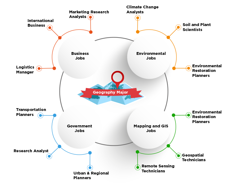
Geography is more than just locating places on the map. Geography is unique in bridging the social sciences with the natural sciences and provides a holistic insight into the world. It is an interdisciplinary science and provides an ideal framework for relating to other fields. This area of study might be for you if you are curious about places across the world, like to look at maps, are a problem-solver or a problem finder, like to work outside, try to see the big picture, and/or can adapt to technological change. Our student tends to be interested in the environment, climate change, wildlife, city planning, and technology (mapping, virtual 3-D, and drones).
Learning that Sticks
What is learning that sticks? How can we teach in a way that students can carry learning with them as they navigate life? One way to deepen learning is to integrate projects into our GIS courses. Students in GIS have the opportunity to work with community partners to create map projects which can be used in local planning projects. We have partnered with organizations, including, the Dayton’s Community and Planning Department, Five Rivers Metro Parks, and the Dayton Collaboratory to complete a number of projects, for example:
- Walkability Study of Downtown Dayton
- Mapping Ecological Corridors in Northwest Dayton
- Dayton Mid-Century Modern Buildings and LEED
- Economic Study of East Third Street
- Walk Dayton Project
- Dayton Neighborhoods Tree Equity Project
Geography/GIS Mission
- Provide students with knowledge about the human and physical processes that shape our global world.
- Foster understanding of human-environment interactions and sustainability.
- Develop abilities of reason, collect and analyze data, synthesize information and draw conclusion and effectively communication with others.
- Provide students with technology skills needed to study spatial relationship students for careers and productive citizenship through lifelong learning.
- Provide students with opportunities to work on collaborative projects in the community and gain first-hand experience through internships.
Specialized Learning Spaces
Center for Applied Social Issues (CASI) Research Center is a computer classroom/lab in Building 12, Room 363 that supports the program/course outcomes of quantitative literacy in Geographic Information Systems and in Geography (GIS).
 Available Programs
The Associate of Applied Science degree in Geospatial Technologies will prepare students for careers and transfer degrees in geographical information systems (GIS). In this interdisciplinary program, students select a pathway specific to their interest: Analyst, GIS Programming Specialist, or Aerial Sensing Data Analyst. In this profession, graduates are responsible for collecting geospatial data, producing maps, analyzing spatial data, coordinating GIS projects, providing technical expertise to clients or users, and providing programming and software development expertise. This degree program contains one or more embedded certificates which will be automatically awarded when the certificate requirements are completed. If you do not want to receive the embedded certificate(s), please notify Registration and Student Records at studentrecords@sinclair.edu.
View Full Program Details
Geography is the study of Earth's landscapes, peoples, places and environments. It provides a knowledge of the Earth's physical and human systems and of the interdependency of living things and physical environments. The Associates of Arts Degree in Geography is designed for students who are planning to transfer to a four-year college or university and pursue baccalaureate degree programs in geography or related fields. The curriculum fulfills the freshman and sophomore general education requirements for most four-year colleges and universities. In addition, the program offers a one-year certificate in Geographic Information Systems. As part of this degree program, students must complete the requirements of the Ohio Transfer 36 in order to graduate.
View Full Program Details
The Geographic Information Systems (GIS) short-term certificate will provide students with both theoretical and practical applications of GIS. The certificate will cover the foundational concepts in GIS, including the principles of cartography and GIS, database management and analysis, data acquisition, and manipulation of georeferencing and geocoding.
View Full Program Details
The Geospatial Technology Analyst short-term certificate will provide students with both theoretical and practical applications of Geographic Information Systems (GIS). The certificate will cover the foundational concepts in GIS, database management and analysis, data acquisition, and manipulation of georeferencing and geocoding.
View Full Program Details
Students learn advanced applications in geographical information system software, ArcGIS; programming skills; how to design and implement websites; design and administer relational databases; query databases using SQL.
View Full Program Details
